
Hiking the Halvor Lunden Trail in Coquitlam, BC
The sun was shining, and the glorious freedom and potential of a Saturday morning had settled over me as we began the first few steps of the Halvor Lunden trail, located on the east side of Buntzen Lake, across from the Vancouver-famous Diez Vistas trail in Coquitlam. I had heard rumours of the untapped potential of the east side trails, but knew few who had gone, and had received warnings about potentially unmarked trails, snow, and frequent search and rescue calls. Today, a bizarrely warm spring day (read: summer day!) seemed like a great chance to put an unknown trail beneath our feet. Like the responsible explorers we are, we packed our ten essentials, plus microspikes for possible snow, and set out.
The Halvor Lunden trail begins from the parking lot of Buntzen Lake, a small, family friendly lake in the Anmore district of Coquitlam. This is my favourite Vancouver-area lake due to its lovely beach, open lawns, and run-able trail network. I’d been coming here for a few years for runs and barbecues, so let me offer one tip: the entrance to the park is gated and parking is limited, so on a hot summer weekend, you need to arrive before 10am, otherwise the lots will be full and the front gate closed. You will be turned away by staff. Don’t learn this the hard way like I did. Luckily we were a few months early for summer madness, and found parking in the first lot easily. From there, walk back along the main road for a minute (away from the parking lots), until you see the signboard that marks the start of the east-side trail system. It will be labelled, “Halvor Lunden” trail, and provides some good route info on the three main loops: the Lindsay Lake loop, the Swan Falls loop, and the Dilly Dally loop.

The route we had chosen was the Swan Falls loop. If completed in the same direction we chose (counterclockwise), the loop consists of a steady incline up to a series of lakes, then a rolling trek along Eagle Ridge, ending a great view on top of Eagle Peak (also known as Mt. Beautiful). From there, a very steep and short descent takes you past Swan Falls, to the BC Hydro powerhouse road at the far end of Buntzen Lake. The final stretch is a gentle 4 km walk from the end of Buntzen along the lakeside trail back to the parking lot. As the descent from the summit past Swan Falls was very steep, I think we choose the right direction – the gradual incline of the ridge was much preferable!
The trail climbs right off the bat, with about half of the entire elevation gain occurring within the first hour up to Polytrichum lookout. Let me tell you, the air was almost 30 degrees Celsius and had the unmistakable smell of warm summer forests as we snaked our way up the winding incline, dripping with sweat, and I began to doubt we’d see much snow at all. The previous weekend had seen us up Deeks Lake in Cypress Provincial Park, and I was expecting to see snow less than or equal to the small amount present on that trail. Boy did I get that one wrong! Another mountain lesson – be prepared for anything! Shortly after the lookout, we began encountering small streams flowing from the lakes above, plus the first sightings of snow.

The snow soon got serious, with several feet still lingering at higher altitudes and in the colder pockets of air surrounding the lakes. As we were currently experiencing an extended pattern of unseasonable hot weather, the snow was rapidly melting, leading to extremely unstable conditions. While we tried to step only in the most packed-looking areas, we were in a constant state of readiness for a foot to plunge straight through up to a knee or father, sometimes into icy water below. Despite my waterproof hiking boots, my socks and boots were soon soaked, as ice was constantly getting inside from the top. I was hot on top due to the warm weather, but my feet were a cold mess – I had hoped that would even out to a neutral temperature, but turns out I was just two kinds of uncomfortable!


At the first junction, we elected to keep right, towards the ‘lakes district’ (and not left to the El Paso trail and Eagle Ridge). This took us around a number of small, slowly unthawing lakes. Eventually, we met up with the other trail past Lindsay Lake, where the flags led us back into the trees across the ridge. It was very slow going through the lakes, as the snow was thick and unstable. After the lake section, when the snow-covered terrain began to get more steep, we elected to put on our microspikes for some extra traction, rather than risk those icy hills on bare legs (we were wearing shorts and tshirts due to the heat, after all).


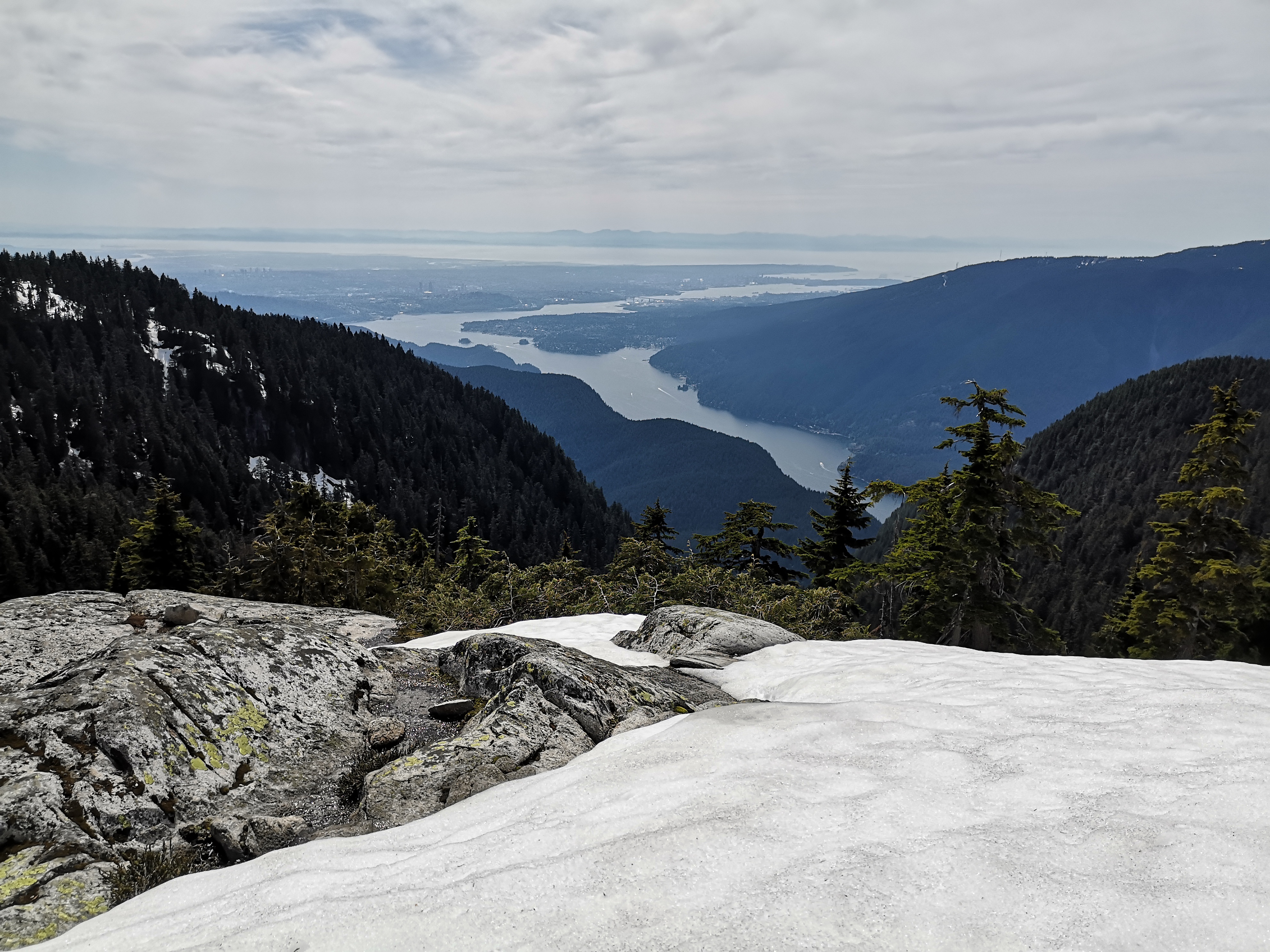
We had lunch at “TT Top”, a high point on the ridge that offered sneak peaks of the view to come. Sitting in the sun with our socks off to dry was very pleasant! From here, we reached the final summit – Eagle Peak – in about an hour. The summit offers stunning views of the mountains of the North Shore and Golden Ears Park, including the current object of my mountain fantasies – the twin-peaked Mt. Judge. Plus, we were also treated to a look at Coquitlam Lake (a rare sighting, as it’s a protected watershed area, and is thus off-limits). Far off in the distance loomed King Baker, dominating the skyline. Right below us was the Diez ridge on the other side of Buntzen, Indian Arm and Deep Cove in North Vancouver, plus the city of Vancouver itself leading to the ocean and the distant haze of Vancouver Island shimmering on the horizon. The summit itself was a treat – large islands of warm granite rose out of the snow, which we ascended with the help of fixed line. Here, we took off our wet boots and socks, and walked barefoot on the hot stone to soak up the views. I’ll confess to not applying sunscreen, and had a pretty good sunburn by the time I got home!


After a luxurious hour on the summit, we resumed the loop – passing through the summit, the trail soon heads sharply down. After about 10 minutes, we came to a junction. Here, you can continue straight to complete the Dilly Dally Loop (adding an extra 5 km to your day), but we elected to take the steep path down the ravine to the left, which led us straight down the mountain past Swan Falls to Buntzen Lake below. Due to the steepness, we only had to put up with another 20 minutes of snow before it was all gone.
As we descended towards the lake, we could hear the roar of Swan Falls below us growing. We eventually reached two good viewpoints, about 10 minutes apart, and paused here for pictures and snacks.


The air grew warmer as we descended, and finally we struck the powerhouse road and the shore of Buntzen. From here, we followed the wide, gravel road for about 10 minutes to North Beach, then took the lake trail back to the South Beach and parking lots. I wondered what the casual strollers on the busy and gentle lake trail thought of us as we wearily walked by – dirty, wet from snow, spikes jingling on our packs, and complaining loudly about even the slightest incline. With the distance, snow, and route finding required on this trip, I’d classify this one as a proper adventure.

Trail Stats
The Swan Falls loop took us about 8.5 hours, with a few very generous breaks (about 1.5 hours of breaks in fact). We clocked in at just under 20 km for distance, and 1150 m of elevation gain. We are fast hikers, but the snow slowed us down considerably.


While I think the Halvor Lunden trail would be a relaxed, half-day trip in the summer, the heavy snow completely obscured the path, meaning that some route finding was required. Luckily, the route is well-flagged, and we had a good trail map/GPS, but we did have a number of stops to spread out and search for the next marker. For this reason, I wouldn’t recommend beginner hikers tackle this one in the winter or spring, unless you’re properly prepared!
My one regret is that I didn’t get to experience the entirety of the trails – Dilly Dally remains unconquered. Ever tried that loop? Tell me what I missed in the comments below!

I don’t even know how I ended up here, but I thought this post was good. I do not know who you are but certainly you are going to a famous blogger if you aren’t already. Cheers!
LikeLike
Haha thanks Leon! I’ll settle for a semi-known blogger 😉 All the best!
LikeLike
Loads of excellent writing here. I wish I saw it found the site sooner. Congrats!
LikeLike
Thanks so much Kimberlie! Really appreciate it, and glad I can offer something of value 🙂
LikeLike