
A guide to kayaking the Broken Group Islands off the west coast of Vancouver Island
Despite being a somewhat casual kayaker, there are a few classic local kayak trips that even I have heard of: Indian Arm, Alouette Lake, and the Broken Group Islands. Being an explorer at heart, when the opportunity arose to make one of these a reality, how could I possibly say no? And so I found myself stuffing gear into dry bags, pondering how the salt water would affect my hiking boots and biking gloves, and studying maps of the Broken Group Islands (BGI), just south of Ucluelet in Barkley Sound on the west coast of Vancouver Island.
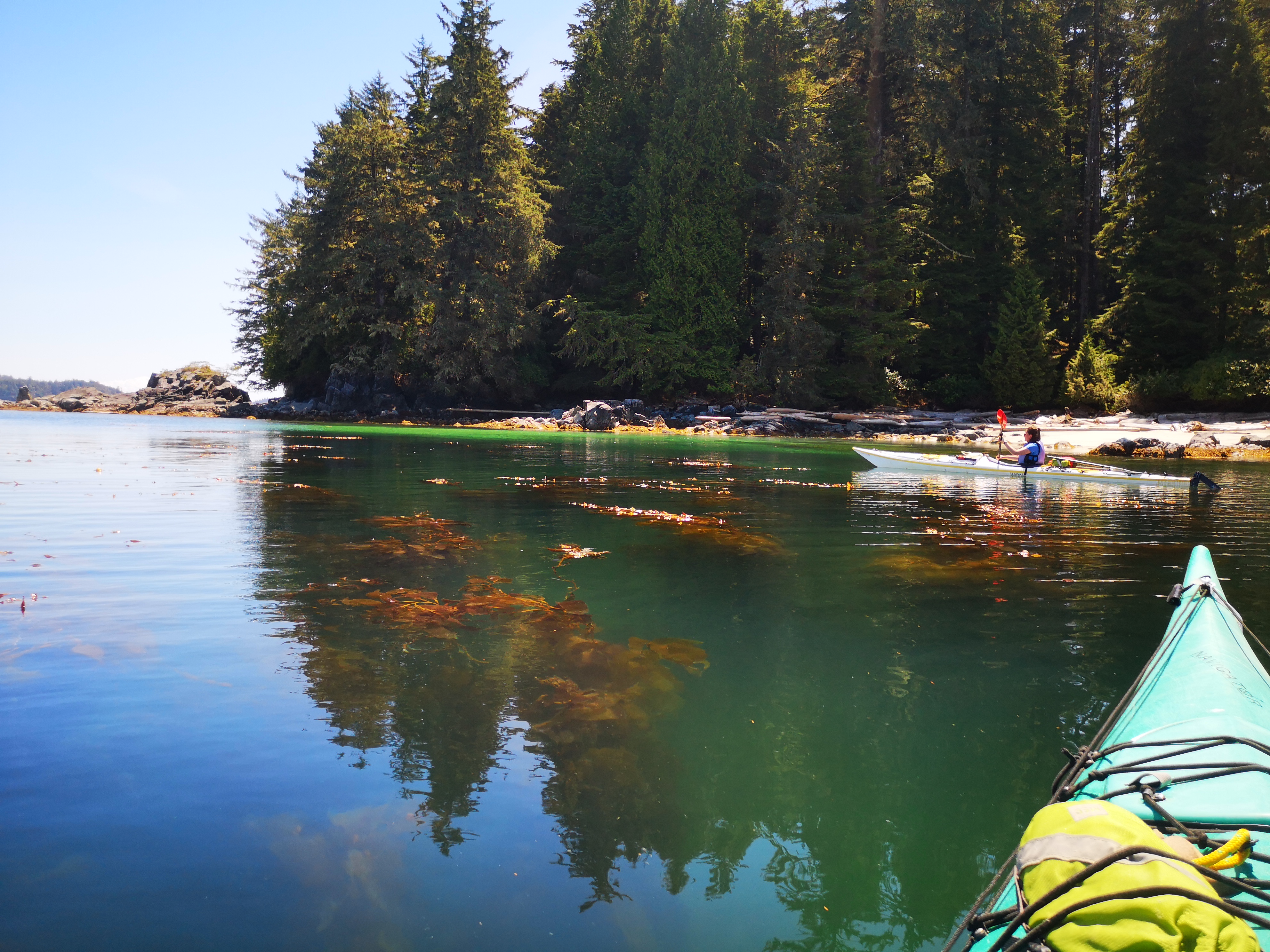
BGI is in Pacific Rim National Park, a beautiful and wild coastal rain-forest. While much of the park is boarded by the full unsheltered brunt of the Pacific Ocean (read: huge waves), the kayaking in the BGI is suitable for beginner paddlers without a guide as the area is sheltered from most of the violent waters. While you may experience some rolling waves and small whitecaps if you venture into the less-sheltered channels, it’s nothing a new paddler on a sturdy sea kayak can’t handle. Why visit BGI you might ask? To experience the full beauty of the remote west coast: misty shorelines, sun-drenched and silent forests, the irresistible smell of salt-water, turquoise oceans lapping up white sand beaches, serene and ultra-clear water, a million chubby orange and purple sea-stars, paddling through twisted ancient trees clinging to dramatic cliffs like a garden of Bonsais while eagles fly overhead – this corner of the world is truly majestic.


Below you’ll find a guide to planning a kayak trip to the Broken Islands Group, including the logistics of getting there and finding yourself in a kayak, some essential kayaking gear to pack in addition to your camping gear, and some tips so you know what to expect. You’ll also find some details of my four day trip, with some trip highlights to get you inspired. Read on paddlers!
How to Prepare
Basically, you need to make camping and boat reservations, get to Vancouver Island, drive across it to either Port Alberni or Ucluelet, get passage across the unsheltered ocean to the Broken Group (or kayak that if you’re very experienced), get kayaks, then go!

- Getting to Vancouver Island: plan to take a BC Ferry into Nanaimo (either via Duke Point in the south or Departure Bay in the city). If you go on a long weekend like I did, I highly recommend making ferry reservations, as the island gets absolutely packed on holidays.
- If you own kayaks and have some ocean experience, you can launch your boats from Secret Beach, near Ucluelet on the west coast of the island. However, this route involves some rougher ocean crossings, and it takes a day to reach the edge of the BGI, so it’s not recommended for less-experienced kayakers.
- If you need to rent kayaks, make reservations with Lady Rose Marine Services. They provide passenger ferry service from Ucluelet or Port Alberni to Sechart Lodge, directly beside the BGI, as well as kayak rentals through Sechart Lodge. Observe the ferry times and directions closely – they only run Monday, Wednesday, and Friday, and will only stop at the place you need in the direction you need once a day. We chose to catch the ferry from Ucluelet, as the timing worked out much better.
- Select some campgrounds in the BGI and make reservations on the BC parks website. Camping is available on Hand, Turret, Gibraltar, Willis, Dodd, Clarke, and Gilbert islands (we had heard that Clarke is the best, and after seeing it, I definitely recommend). If you have a long day of travel, consider making reservations on the first day for one of the closer islands (Hand or Gibraltar), which are only an hour paddle from Sechart Lodge. Camping permits are about $10 per person per night (as of June 2019).
- Grab a National Park entry pass online for your group, as you’ll be staying in Pacific Rim National Park.
- Grab a map and a tide chart – while BGI charts are available for sale at Sechart Lodge ($22), they were sold out when we arrived! Luckily, we had grabbed a decent $13 map from MEC before the trip. All the islands can begin to look the same when you’re in the water, but with the map, a tide chart from the internet, and a GPS, we did just fine getting around.
- Print your documents: the ‘Beachkeepers’ maintain the campsites, and may ask to see your camping permits and park passes. Print your maps and tide charts also. Keep everything in clear, waterproof bags for easy reference.


Gear to bring
- Water – there is no fresh water available in the BGI, so you need to bring everything in with you. The park recommends 4-6 L of water per person per day. For our group of 4 on a 4 day trip, we brought 80 L (4 x 20 L water ‘cubes‘). This proved to be a TON of water. Even with some hot, sunny days and rather wasteful consumption, we only went through about 40 L. But better to have too much than not enough!
- Dry bags – You can count on getting wet on this trip, but that doesn’t mean your gear has to be! Kayaks aren’t quite watertight, so keep anything that can’t get wet (extra clothes, your sleeping bag and mat, electronics, maps and permits, your cardboard box of pancake mix, etc.) in dry bags. Keep in mind the dimensions of the kayak hatches; it’s easier to get smaller bags through these than larger ones, so aim for a larger amount of smaller bags instead of one big bag.
- Gloves – if you’re like me, you get blisters after a day of paddling. Apprehensive about 4 days of wear and tear on my hands, I brought my bike gloves. No blisters after 4 days! Bring gloves with smartphone compatible fingertips for picture-taking ease.
- Waterproof phone case – I have one with two clear plastic windows: one for the screen, and one for the camera lens – it was great being able to take pictures on the water without having to take the phone out of the case every time
- Extra dry clothes – bringing paddling clothes, camp clothes, and sleeping clothes is a good idea. Remember that you’re in a rain-forest; it is extremely humid, even on summer nights, and rain and fog are always likely. Pack like none of your clothes will dry, and consider it a bonus if they do.
- Sandals – you’ll be in and out of the water loading and launching the boats, plus some of the beaches are very sandy, so it’s good to have sand- and water-friendly footwear.
- Navigation – as mentioned above, maps, tide charts, GPS – whatever you need to feel confident in getting around.

Tips
- The islands are lot harder to hike around than you’d think, due to cliffs, thick undergrowth, rising tides, and a lack of established trails. I didn’t really get much walking in at all.
- There are outhouses at all campsites (which were actually of decent quality), but no other services (like running water, garbage bins, or bear/animal caches). Follow the ‘pack in, pack out’ and ‘leave no trace’ etiquettes.
- If you’ve never been to the west coast of Vancouver Island before, it is a very different climate than the lower mainland. It is usually much colder and wetter than everywhere else. Count on rain, humidity, mist, fog, and lower than normal summer temperatures, and bring your rain gear.
- The islands are closer together than you might think. You could probably do the whole circuit in one long day. Take your time and enjoy!
- Your paddling power comes from your core, not your arms. Keep your hands wide, and twist a bit with each stroke. Your obliques might be a bit sore after this, but trust me, it’s better than your arms hurting all weekend.
- Stash stuff you might want on top of your kayak (in a small dry bag if needed). Having easy access to snacks, water, and sunscreen is a huge plus.
- You’ll find calmer waters in between the islands and in the mornings when the winds are low. Some crossings of larger channels with rougher waters are required, so plan these for the morning unless you want to fight big swells, winds, and tides.
- While the tides probably won’t make or break you, your experience might be nicer if you’re not fighting the tide or taking the long way around an island because the passage you meant to take is uncrossable. Use your tide chart.
- There can be bears, wolves, and other smaller critters present, even on the farthest islands! Plus a million mice. Securely store all food and scented items (yes, even your sunscreen, deodorant, and dish towels) at night, unless you want mice or something worse to chew through your tent and dry bags. The kayak hatches worked very well for this purpose.
- Campfires are allowed on the BGI! Hurrah! Make sure you build them below the tide line, and nature will take it course and douse it for you. Check out the Pacific Rim park guidelines before you go.
- A complete surprise: full cell reception! I have never in my life done a backcountry camping trip with full connection. While part of me feels like these trips are about getting away from phones, I did enjoy the novelty of being able to google things at our campsites, such as how to cook orzo. At the very least, it meant that this trip was very safe, as we had the ability to send a text or make a call at all times, plus access Google Maps.
- Store your boats above the high tide line at night. It would be the worst to wake up and find that they had floated away. Also, keep a close eye on drinks you’ve left to cool in the water for the same reason…


Our journey
Due to ferry considerations, we began our journey very early, catching the 5 am ferry to Nanaimo via Duke Point. We had a bit of time to explore before beginning our drive across the island to Ucluelet, so we grabbed some coffee and delicious pastries, and checked out Morningstar Farm (home to Qualicum Cheeseworks and Mooberry Winery) in Qualicum Beach. Gourmet cheese, a winery, farm animals, and fully automated cow-milking made for an interesting diversion!


Leaving Qualicum, we began the long drive west on highway 4. After rain, naps, and pastries, we arrived in Ucluelet just before 12 pm, perfectly timed to catch our second ferry. We pulled the car down to Whiskey Landing, at the end of Main Street (beside the aquarium), and unloaded our gear from the car onto the dock just as the ferry pulled up. There is multi-day parking available just down from the dock. Lady Rose Marine provides large bins for group gear, which they load onto the boat with a crane. After seeing our stuff safely loaded, we had an hour before the boat was scheduled to depart the marina. We seized our last chance to indulge in running water and fancy coffees in Ucluelet.


The ride to Sechart lodge was longer than I expected: just under 2 hours. During the last portion of it, the captain took us through the Broken Group Islands themselves, calling out points of interest: Sail Rock (which marks the edge of the archipelago), Effingham (bad ham) island (the largest), Clarke island (that still has the remnants of an old hotel), and Turtle island (haunted. The eccentric hermit Salal Joe lived here alone for years until his empty canoe was found one day). It was a bit depressing to think we would spend days traversing these waters that took 45 minutes to cross in the ferry! We were dropped at Sechart lodge and our gear unloaded by the crew as we got our kayaks sorted out. After the long process of loading them (we brought insane amounts of fresh food and drinks), we were off to our first campsite on Hand Island. We arrived around 7 pm, and, after a very long day of travel, we were happy to eat and get some sleep!


We spent 4 days paddling the islands, cooking elaborate meals, and relaxing on the beaches. The campsites we selected – Hand, Clarke, and Gibraltar – were all quiet and peaceful. While we encountered a handful of other paddlers on the water and on the beaches, it never felt crowded, despite it being a holiday weekend in the height of the summer. On the fourth morning, we set off early to make it back to Sechart lodge to return our kayaks and catch the Lady Rose ferry back to Ucluelet around 11 am. A few hours later, we were loading up the car on the wharf, and after a long wait for a delicious lunch, we were back on highway 4 towards Nanaimo.


As we had reservations for the ferry from Departure Bay around 9:30pm, we had a bit of time to kill, so we spent it island-tourist style: we stopped at Coombs market for delicious gelato, artsy market shopping, and the bookstore, then hung out in the sleepy Nanaimo waterfront until it was time to catch our ferry. By the time we neared Vancouver, it was dark enough for a special treat: all the passengers piled out onto the deck to watch the Canada Day fireworks across the water. Seemed like a fitting end!
Trip highlights
Just a few of the moments that really stood out for me on this amazing trip:
- Teal waters, rocky cliffs, persistent coastal trees clinging to unlikely rocks, underwater kelp forests, crystal clear water… West coast paradise!
- The wildlife – mama and baby deer walking through our campsite at Clarke, a lone humpback whale surfacing all around us as we paddled, chubby sea lions on rocks in the sun, and dozens of hummingbirds. Fortunately, no bears or wolves.
- Real food – as we weren’t backpacking, we gave little thought to the weight of our supplies. We brought all kinds of fresh food. Perhaps the best symbol of our extravagance, the least calorie-dense food I can imagine: an entire watermelon, rind and all.
- Glassy morning water surrounded by misty shorelines, a Margret Atwood-esque Canada: remote, wild, and mysterious.
- Excellent weather – the rain (mostly) held off during our trip. Despite some morning mist, we even got two days of sun, heat, and blue skies! This was the best weather I have ever experienced on the west coast of the island.
- Hunting for a hidden lake with Michael, a solo kayaker I met on Gibraltar. Michael had heard rumours that there was a lake in the center of the island, so we undertook a convoluted, poorly planned, and bushwacky journey to discover it. The trek was a failure, but I got some great tips on the North Coast Trail, a journey I’ll be undertaking later this month.
- The camping treats – from chocolate croissants and strawberry danishes, to maple syrup and pancakes, to mouthwatering coffee shop cookies, to homemade creamy gelato, I probably consumed enough sugar for the entire year.
- Drinking beer and making hot chocolate and ramen noodles on the dock at Sechart Lodge while waiting for our ferry back to Ucluelet.


While I’m a big believer in not repeating trips, as there’s so much to experience in the world, I’d happily return to the Broken Group Islands. There were so many islands we didn’t set foot on, so many little bays and tiny channels we didn’t wander into, that I feel like it could be a whole new trip next time. Hopefully, this guide helped you break down what can be a logistically demanding trip into some easy steps, because this little archipelago is a real gem that you need to explore!
Ever kayaked the Broken Group Islands? What was your favourite campsite? Any crazy wildlife sightings? What was the most excessive, luxurious item you hauled in your boat? Can you top a watermelon? Let me know in the comments below!
For more trip inspo, check out my trips to the Sayward Canoe circuit and Desolation Sound!

wow, Emily! this is a solid trip report/blog on the BGI.
LikeLike
Thanks for checking it out Greg! 🙂
LikeLiked by 1 person
Very nice blog! You covered everything well! I can’t top a watermelon lol! Secret beach is less than a 2 hour paddle to hand island so don’t let that stop people. Just have some form of gps as it is true, the islands look similar and it gets confusing. Cheers!
LikeLike
Haha yeah a watermelon was a little silly. Secret beach, huh? I am already excited to go back there! Thanks for reading Pat! 🙂
LikeLike
Planning a trip for this summer and this was super helpful, thanks!
LikeLike
Glad you found it useful Jaiden! 🙂
LikeLike
thank you! Going with a group, and the first day will just be me and one other as our group will be ahead of us. We are starting at Secret Beach to Dodd then Clark then Hand apparently. As I am unfamiliar this was great info to getting me started and valuable info. !
LikeLike
Awesome, so glad you found it useful! Enjoy your trip! It’s a paradise out there.
LikeLike